|
||
|
||
| House
at Çatalhöyük (HATCH)
What is Hatch? Hatch (House at Çatalhöyük) is an IT platform in the form of MIODEC (Multi-dimensional Interactive Open Digital Educational Collection). It is an advanced and innovative class of systems designed to create and maintain digital collections. Hatch is aimed at presenting a wide range of data about the Neolithic settlement at Çatalhöyük in a multiscalar and interactive form, linking information of different characters (types of objects, relations among them, etc.) with different forms of their presentation (text, photographs, graphics, etc.). It has didactic objectives and is designed to meet the needs and expectations of both professionals and the general public interested in the human past.
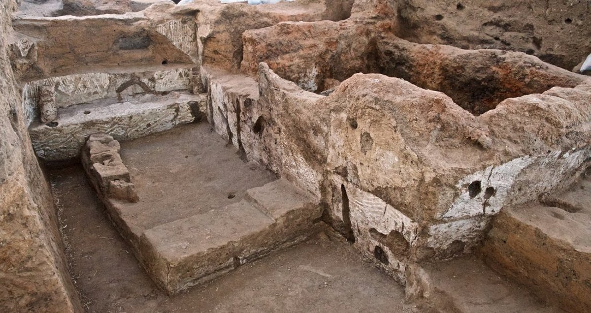
Buildings are the main
type of objects presented within Hatch. These are used to aggregate a wide
range of other categories of objects found at this settlement. These include:
imagery, burial, figurine, clay object, chipped stone, ground stone, worked
bone, pottery, stamp seal and animal bone. The auxiliary entities used
to aggregate different types of objects are special deposits and finds.
Each category of objects are described according to a set of predefined
attributes. These are divided into two categories: (i) general and (ii)
specific. The former comprising of dating, year of discovery, size and
textual descriptions. The latter including, the number of rooms, house
constructional elements, decorative motifs, among others. A wide range
of filters enables the user to display the data according to different
needs by expanding and narrowing the queries.
Presentation of Data Hatch presents the stored data in the form of three intertwined modes: (i) typological, (ii) spatial, and (iii) chronological. The typological mode presents information in a database format, namely a list of objects displayed according to the specified filters. Data in the spatial mode is displayed in the form of GIS objects placed in the scaled cartographic map (based upon Open Street Map). The chronological mode involves presentation of both relative and absolute chronologies. When presenting relative chronology, the objects are tagged by one or more mutually exclusive forms of relative chronology of the settlement: Hodder Phase, Mellaart Phase, and TP Phase. As of today, both Hodder and Mellaart Phases are not yet reliably translated into absolute chronology. Hence, buildings from corresponding occupational areas and stages of the settlement development are only presented in the form of relative chronology. Both relative and absolute chronologies are available for strata featured by TP Phase. Data can be displayed in a wide range of different formats thanks to the advanced search engine. It operates in two modes: (i) word search and (ii) tag search. The word search facilitates access to the stored data by attributes of a textual type. The tag search makes it possible search the data by tags attached to the objects as attribute values. In both cases, the user can enhance the search by selecting thematically linked tags. The search engine makes it possible to prompt tags semantically linked to the enter word by referring to relations from the adopted wordnet based ontology. The data stored within
Hatch can be displayed in an interactive form. From the typological format
of presenting objects, the user can go directly to more detailed presentation
of its different aspects. These shall comprise textual data, detailed plans
of the buildings and photographs. Any object can also be easily displayed
in either spatial or chronological mode.
Goals of Hatch Hatch is a tool to serve
explicitly didactic goals. It makes it possible to explore the stored data
in the multiscalar forms responding to a wide range of needs and questions
posed by the user. In particular, it serves the needs of the general public,
as well as members of archaeological community who are not experts in Çatalhöyük
and the Near Eastern Neolithic. The solution shall facilitate an in-depth
understanding of different aspect of existence of this renowned settlement.
Users start interacting with the tool by asking a range of simple questions
and can further explore the repository by asking more advanced questions
and delving into the previously unthinkable aspects.
Hatch Production Process Hatch was designed and created by archaeologists - members of the Çatalhöyük Research Project team, and IT specialists from Adam Mickiewicz University in Poznań, Poland - in collaboration with other Çatalhöyük project members. Hatch contains data collected manually from a wide range of publically available materials. These include publications (monographs, excavation reports, journal articles) and open access archaeological databases (Çatalhöyük Excavation Database, GIS database, Çatalhöyük Photograph Portfolio etc.). Publication and analysis of the excavation data is ongoing and therefore some aspects of the data is subject to future revision. At the present, the databank contains 139 buildings. A separate number has been
allocated to any structure that could be interpreted as a building. Altogether,
167 numbers have been assigned to buildings to date. In some cases, the
number was taken out and later deleted for a range of different reasons.
The house numbers that do not exist are the following: 11, 15, 19, 26,
27, 28, 29, 35, 36, 37, 38, 39, 90, 99, 117, 149, 151, 153, 154, 155, 156,
157, 158, 159.
Hatch Team Project design and coordination:
Arkadiusz Marciniak
Acknowledgments All visual materials contained on this site are the property of Çatalhöyük Research Project. Praca naukowa finansowana ze środków finansowych na naukę w latach 2013-2018 przyznanych na realizację projektu międzynarodowego współfinansowanego (Nr 3085/Kultura/2014/2) Hatch has been produced
with the support of the European Commission (through the Culture 2007-
2013 programme) in the framework of the NEARCH Project New scenarios for
a community-involved archaeology. This publication reflects the views only
of the authors, and the Commission cannot be held responsible for any use
which may be made of the information contained therein.
|
|